
Centre Calgary · inner city
Ramsay
Ramsay is four subdivisions on a hill, built for the people who worked below it.
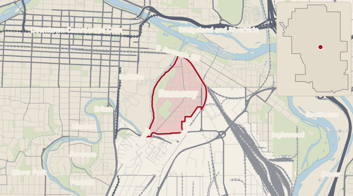

Ramsay is one of the oldest neighbourhoods in Calgary and the clearest surviving example of a working-class one. It was assembled from four separate subdivisions between 1887 and 1906, and the people who bought into it worked at the three industrial employers at the bottom of the hill. About half of the detached houses still standing were built before 1920. The escarpment looks straight across at downtown, and for ten days in July the neighbourhood lives next to the Stampede.
Where. Ramsay is east of the Elbow River and south of the Stampede grounds, on the hill above the rail yards. Bounded by the Elbow River on the west, the Stampede grounds and Macleod Trail beyond it, the CPR main line and Inglewood to the north, and the Alyth yards to the east.
A day in Ramsay
Ramsay is a hill with a view at the top and breweries at the bottom, and the day runs between them. From Scotsman’s Hill, the open ground along Salisbury Avenue above the Stampede grounds, the downtown skyline sits across the river, and stairs go down to the Elbow. It is where the neighbourhood watches the fireworks in July, and on an ordinary evening it is where people walk the dog. The off-leash area is at 811 Macdonald Avenue, near Bellevue and 7 Street.
Coffee is thin. The two cafes are both in old industrial buildings: Rosso in the 1927 Riverside Iron Works plant on 24 Avenue, and the roastery in the 1911 C.C. Snowdon oil building at 2020 11 Street SE. Breakfast is Red’s Diner on 8 Street. The afternoon and evening belong to the breweries: Dandy’s tasting room on 11 Street in a former motorcycle shop, and Good Cheer, which opened in the Ramsay Design Centre in December 2025 brewing historical styles. For a grocery or a bookshop people cross the tracks to Inglewood’s 9 Avenue. That is a fifteen-minute walk from most of Ramsay since the 8 Street crossing closed in 2020; the route is now under the 9 Avenue bridge or around by 11 Street.

Ramsay at a glance
- To sell, over the twelve months to October 2026
- 33 days
- 24 homes sold. Calgary: 30 days.
- Median assessed value, 2026
- $742K
- Calgary: $621K. Property tax on it: $4,930 a year.
- Designated elementary schools, 2026-27
- Ramsay School; St. Monica School
- High school: Western Canada High School; St. Mary's High School.
Data is deemed reliable but is not guaranteed.
Own a home in Ramsay?Thinking of living in Ramsay?
How Ramsay came to be
The land before the city
Ramsay is within Treaty 7 territory.
Heritage Calgary’s context paper records that the escarpment and valley at Ramsay drew migrating bison, and that First Nations travel followed the Old North Trail, an ancient north-south route that forked near the site of present-day Calgary. The alignment survives in the street grid: the trail became Macleod Trail and then, in 1967, Spiller Road south of the escarpment and 8 Street SE north of it.
The earliest documented non-Indigenous settler in east Calgary was Louis Roselle, 1821 to 1891, a Métis former buffalo hunter who homesteaded land spanning what is now Ramsay and Inglewood. His claim is where the neighbourhood’s paper trail starts.
Why it was built
Ramsay was assembled from several subdivisions rather than laid out at once, which is why the street pattern changes as you cross it. Wesley Fletcher Orr bought Roselle’s claim in 1883, the year the CPR main line reached Calgary, and registered Plan A2 in 1887, east Calgary’s first subdivision, running south from the Bow River to 17 Avenue. Plan 2789 followed in 1904, registered by Maggie Beattie with Mary Schreiber and A.F.H. Mills, west of what is now Maggie Street. Adam Francis Mills registered Plan 4040N in 1906 for Mills Estates, east of Spiller Road. In the same year William T. Ramsay subdivided the escarpment as Grandview Heights, setting a $2,000 minimum building cost to attract buyers of means.

Ramsay joined Calgary in stages between 1884 and 1907: the northern part of Section 14 was inside the original 1884 Town of Calgary; a small industrial area east of 11 Street SE was annexed in 1903; the northwest of Section 11 in 1906; the remainder of Ramsay in 1907. Demand came from walking distance to the CPR yards and east-end industry, and the Burns Avenue streetcar line, which ran from 1911.
Read more about how Ramsay came to be
Who built it
Ramsay is partly built of its own ground: sandstone from the Elbow River Quarry and the Scotsman’s Hill area went into local landmarks, Ramsay School among them. Forty-one per cent of Ramsay’s first or second residents worked for three industrial employers, the CPR alone about 35 per cent, with Burns and the stockyards and the brewery making up the rest. The population was mixed in origin, including Scottish, English, Russian Jewish and Japanese-Canadian residents.
Ramsay’s most consequential planning event came in 1974, when the Ramsay-Inglewood revitalization put $5.6 million of federal Neighbourhood Improvement Program money across roughly 900 homes, with four stated objectives: regenerate the housing stock, reduce industrial impacts, down-zone to end speculation, and improve public amenities. Heritage Calgary credits it with keeping the single-family character while allowing a modest increase in density. That is a large part of why so much pre-1920 housing survives this close to downtown.
Ramsay’s industrial buildings are being reused rather than replaced. The Standard Soap Company building at 1240 20 Avenue SE, built 1905, is now LocalMotive Crossing. The Dominion Bridge and Riverside Iron Works plant at 803 24 Avenue SE, built 1927, is on the heritage inventory. The City’s dataset lists 36 Ramsay properties on the inventory, 5 of them demolished, and marks two as municipally designated: the Snowdon building and the 9 Street boulevards. Ramsay House at 2004 Salisbury Street, 1913, is on the Alberta Register.

The streetcar
The Macdonald Bridge opened in 1910, and from 1911 streetcars crossed it into Ramsay and ran along Burns Avenue toward the Burns packing plant. That line, later part of the Sunnyside to Burns route, let workers live within a short ride of the plant and the rail yards. Its last run was in 1950.

Daily life in Ramsay
What is here
What is here, measure by measure
| Here | Typical community | |
|---|---|---|
| Transit routes | 3 | 5 |
| Transit stops | 27 | 27 |
| Pathways | 1.6 km | 2.8 km |
| Bikeways | 3.6 km | 1.7 km |
| Parks and open space | 20.0 ha | 23.3 ha |
| Playgrounds | 1 | 3 |
| Places to eat and drink | 13 | 16 |
| Shops | 25 | 14 |
| Salons, spas and similar | 13 | 8 |
| Off-leash dog areas | 2 |
Nearest
| Library, Central Library | 1.3 km |
| Pool and fitness centre, Inglewood Aquatic Centre | 1.0 km |
| Hospital, Rockyview General Hospital | 6.2 km |
As of November 2026.
Streets and trees
Streets and trees
The streets change character as you cross Ramsay because the four subdivisions were laid out by four different people. Mills Estate, east of Spiller Road, is cottages on 25-foot lots; Grandview, on the escarpment, was subdivided in 1906 with a $2,000 minimum build cost to attract bigger houses. The City maintains 1,022 trees on public land in Ramsay, 624 of them on the street side, 0.55 per dwelling. Street trees average 26 centimetres across and the largest is 86. That is thinner than in a 1950s suburb with one per home, and the reason is lot width: a 25-foot lot has room for one boulevard tree, not two.
American elm and green ash are Ramsay’s street trees, 379 between them in the City’s tree inventory. What is distinctive is what grows on the slopes and in the lanes: 109 cotoneaster and 103 caragana, the hedge plants of old east Calgary, and 63 Manitoba maple, the tree that seeds itself in a lane and gets left. The 67 bur oak are newer City plantings. There are fewer conifers than in the suburbs; this is a deciduous neighbourhood that goes bare in November.
One Ramsay street is on the heritage inventory as a landscape: the 1100 block of 9 Street SE from 17 Avenue to Adelaide Road, a 1929 boulevard planted under parks superintendent William Reader. It is municipally designated.
Most common species, City trees
| Species | Count |
|---|---|
| American elm | 211 |
| Green ash | 168 |
| Bur oak | 67 |
| White spruce | 66 |
| Manitoba maple | 63 |
| Colorado spruce | 48 |
| Nanking cherry | 40 |
| Schubert chokecherry | 39 |
| Northwest poplar | 37 |
| Brandon elm | 30 |
City-maintained trees only; the inventory also logs 109 cotoneaster, 103 caragana and 66 lilac as shrubs, left out of the table. Trees on private lots are not counted.
Trees
As of October 2026, the City looks after 1,022 trees on Ramsay’s streets and in its parks, about 1.2 for every home. Elm, ash and spruce are the most common types.
Shops, food and drink
Shops, food and drink
Ramsay’s businesses are in its old factories. The Snowdon oil works, the Riverside Iron Works, the Standard Soap building and the Ramsay Design Centre are all working buildings again, with breweries, roasters and design studios where the industry was. The list is short because the neighbourhood is short on retail; Inglewood’s 9 Avenue, across the tracks, has the rest.
- Dandy Brewing Company and Tasting Room since 2014; on 11 Street since 2018Brewery and kitchen in a former motorcycle shop, the anchor of the 11 Street block.11 Street SE
- Good Cheer Brewing since December 2025Historical beer styles in the Ramsay Design Centre; the bar is built from oak reclaimed from a Mount Royal mansion.1220 20 Avenue SE
- Calgary Heritage Roasting Company since 2019Cafe and roastery inside the 1911 C.C. Snowdon oil building.2020 11 Street SE
- Rosso Coffee Roasters, RamsayCafe in the 1927 Riverside Iron Works / Dominion Bridge plant.24 Avenue SE
- Red's DinerBreakfast and lunch, the Ramsay location of the small local group.1101 8 Street SE
Getting around
Ramsay is closer to downtown than its transit scores suggest. Walk Score for the service area is 32 and Transit Score 51, but Bike Score is 81. On a bike, downtown is ten minutes over the Elbow and through the Stampede grounds or East Village; on foot or by bus it is slower than the distance says. Route 17 Renfrew/Ramsay runs from Macdonald Avenue through downtown.
Read more about getting around
Two things have changed Ramsay’s map since 2020. The 8 Street SE crossing of the CP tracks, the direct way into Inglewood, closed on January 15, 2020 as part of CP’s reconfiguration and the Green Line land deal; the detours are under the 9 Avenue bridge by the river pathway or east by 11 and 12 Street. And the Green Line survived its 2024 reset. The southeast segment is under construction with a 2031 opening, and both the Ramsay/Inglewood and 26 Avenue SE stations are on the current plan, on elevated track along the rail edge. The first Green Line work in Ramsay was the demolition of the Lilydale poultry plant by the 12 Street rail bridge in November 2023; the site is now a staging yard.
More on getting around and daily life: driving, transit, shops, child care, parks, planning
Driving times with no traffic
| From the centre of Ramsay to | By car | By road |
|---|---|---|
| City Hall | 5 minutes | 2.3 km |
| The University of Calgary | 19 minutes | 12.1 km |
| Foothills Medical Centre | 17 minutes | 9.6 km |
| The airport | 19 minutes | 17.2 km |
The quickest route at the posted speeds, with no traffic. Rush hour takes longer.
Transit service
Ramsay has 27 transit stops served by 3 regular routes. On a weekday morning the most frequent route comes every 15 minutes. The first departure is at 5:09 am and the last at 1:00 am. The busiest routes are route 302 BRT Southeast/City Centre (every 15 minutes at the peak), route 24 Ogden (every 30 minutes at the peak) and route 17 Renfrew/Ramsay (every 30 minutes at the peak). From the centre of the community, the nearest C-Train station is Victoria Park / Stampede, 1.2 km; the nearest MAX rapid bus station is 9 AV @ 8 ST SE, 0.8 km.
Paths and bikeways
Ramsay has 1.6 km of pathways and 3.6 km of bikeways, 0.5 km of them separated from traffic.
Shops and services nearby
Within a kilometre of the centre of Ramsay, OpenStreetMap shows 1 supermarket, 7 other grocery shops, 4 pharmacies, 2 medical clinics, 9 cafes and 19 restaurants. The nearest supermarket on the map is The Silk Road Spice Merchant, 0.9 km away.
Child care
Ramsay has 1 licensed child care program with 70 spaces, about 47 for every 100 children under five at the 2021 census.
Parks and tree cover
Ramsay has 20.8 hectares of parks, 21.1% of its land and about 97 square metres for each resident. Trees covered 15.9% of the community in 2022.
Water mains
The City recorded 13 water main breaks in Ramsay from 2016 to 2025, the most on Bellevue Avenue SE (3). Since 1958 there have been 126 breaks.
Planning and building
Ramsay is covered by the South Bow Communities Local Area Plan, in preparation. Since 2021 there have been 12 applications to change land use, 9 approved and 1 still under review. Building permits were issued for new homes: 94 in 2023, 16 in 2024 and 5 in 2025. The planned Green Line station at Ramsay / Inglewood is 0.5 km from the centre of the community.
Source: OpenStreetMap roads, November 2026; Calgary Transit schedule for 17 November 2026; City of Calgary pathways and bikeways; OpenStreetMap places, November 2026; Government of Alberta child care licensing, programs inspected in 2023; City of Calgary parks, and tree canopy 2022; City of Calgary water main breaks; City of Calgary land use applications, building permits and plans. Data is deemed reliable but is not guaranteed.
Parks and recreation
Parks and recreation
Ramsay’s park is the hill: Scotsman’s Hill, which is not a City park with a sign but the open escarpment above the Stampede grounds along Salisbury Avenue, named for Angus Fraser, the Hudson’s Bay man who homesteaded the east bank of the Elbow in 1881. It has the skyline, a trail to the top, stairs down to the river and, in July, the fireworks. The Elbow River pathway runs along the west edge under the CP bridge to 8 Street and 9 Avenue, and connects to the Bow pathway system through Inglewood.
The Ramsay community association hall on 8 Street has a licensed hall and a lounge, and the association floods an outdoor rink in winter; a children’s garden is planned. Across the river, Lindsay Park and the MNP Centre are the nearest big recreation facility, a short ride through the Stampede grounds. For ten days each July, west Ramsay has vehicle barriers from about 7 to 11 each evening, with entry only for residents’ plates or permit holders, and the permits are mailed to the houses that need them.

Who lives in Ramsay
At the 2021 census, Ramsay was a young, educated, half-renting community of small households: 55 per cent of households owned and 45 per cent rented. Forty-four per cent of residents moved in within the last five years. Nine per cent are 65 or over, against 13 per cent citywide. Median household income is $97,000, against $98,000 for Calgary, and 42 per cent hold a bachelor’s degree or higher.
Read more about who lives in Ramsay
Ramsay has a hundred-year-old housing stock, a Bike Score of 81, and arts and design businesses in the Burnsland industrial buildings. Ramsay has 43 approved secondary suites, 5.0 per 100 parcels, among the highest rates in the inner city. Fifteen per cent of residents are under 15, and the school at the top of the hill has 279 students.
Source: Statistics Canada, 2021 census.
More about who lives here
More about who lives here
Ages of residents
- 0 to 1415%Calgary 18%
- 15 to 248%Calgary 12%
- 25 to 4440%Calgary 31%
- 45 to 6427%Calgary 26%
- 65 and over9%Calgary 13%
The thin bar is Calgary.
| Here | Calgary | |
|---|---|---|
| People per household | 2.2 | 2.6 |
| Born outside Canada | 14% | 33% |
| Arrived in Canada from 2016 to 2021 | 3% | 6% |
| Post-secondary certificate, diploma or degree | 66% | 61% |
| Households spending 30% or more of income on shelter | 23% | 23% |
| English not the main language at home (2016) | 4% | 18% |
| Other languages spoken most at home (2016) | Dinka, Spanish, Italian | Punjabi, Mandarin, Tagalog |
As of the 2021 census, except where a year is shown.
Schools
Designated schools in Ramsay
| Regular program | Calgary Board of Education | Calgary Catholic |
|---|---|---|
| Elementary | Ramsay School | St. Monica School |
| Junior high | Rideau Park School | St. Monica School |
| High school | Western Canada High School | St. Mary's High School |
These are the designated schools for Ramsay in the 2026-27 school year. Where more than one school is listed, a boundary runs through the community and the address decides.
Schools in Ramsay
| School | Board or type | Grades | Students | For Ramsay |
|---|---|---|---|---|
| Ramsay School | Calgary Board of Education | Kindergarten to grade 6 | 279 | Designated school for Ramsay |
| St. Anne Academic Centre | Calgary Catholic | Kindergarten to grade 12 | 1,248 |
Every school inside Ramsay, from the Province’s school list of November 2026. Students counted 30 September, 2025-26 school year; n/a means no count is published for that school. Designations are for the 2026-27 school year.
French immersion, bilingual and other programs for Ramsay
| Program | Board | Designated schools, with grades |
|---|---|---|
| Arts-centred | Calgary Board of Education | Willow Park School (5 to 9) |
| Chinese (Mandarin) bilingual | Calgary Board of Education | Highwood School (K to 4); Midnapore School (K to 4); Colonel Irvine School (5 to 9); Harold Panabaker School (5 to 9) |
| Early French immersion | Calgary Board of Education | William Reid School (K to 4); Elboya School (5 to 9); Western Canada High School (10 to 12) |
| International Baccalaureate diploma programme | Calgary Board of Education | Western Canada High School (10 to 12) |
| Late French immersion | Calgary Board of Education | Elboya School (7 to 9); Western Canada High School (10 to 12) |
| Montessori | Calgary Board of Education | Killarney School (K to 6) |
| Science | Calgary Board of Education | Riverside School (K to 9) |
| Spanish bilingual | Calgary Board of Education | Glenmeadows School (K to 6); A. E. Cross School (7 to 9); Crescent Heights High School (10 to 12) |
| Traditional Learning Centre | Calgary Board of Education | Glamorgan School (K to 9) |
| Advanced Placement | Calgary Catholic | Our Lady of the Rockies High School (10 to 12) |
| French immersion | Calgary Catholic | Holy Name School (K to 6); Madeleine d'Houet School (7 to 9); St. Mary's High School (10 to 12) |
| International Baccalaureate | Calgary Catholic | St. Mary's High School (10 to 12) |
| Spanish bilingual | Calgary Catholic | St. Margaret School (7 to 9); St. Francis High School (10 to 12) |
The schools a home in Ramsay is designated for in each program, 2026-27 school year. K is kindergarten. 7 more programs have one school for the whole city: see Schools.
Ramsay has its own elementary school, and it is the building that defines the top of the hill. Ramsay School at 2223 Spiller Road, built in 1912 in local sandstone to a design by Hugh McClelland, is the only one of Calgary’s four large 1912 sandstone schools still intact and still a school. It is K to 6, with 279 students. The junior high designation changed in 2025: Ramsay and Inglewood students moved from Rideau Park to Elboya for Grades 7 to 9. The Catholic board’s presence in Ramsay is St. Anne Academic Centre on 21 Avenue, a home-study and distance-learning centre, not a neighbourhood school.
How full the schools are
The public school in Ramsay has room by the Calgary Board of Education’s measure. Across the city, 73 per cent of public schools are.
School by school
| Public school | Students | Capacity | Utilization |
|---|---|---|---|
| Ramsay School | 282 | 349 | 81% |
September 2025. Private schools are not counted.
Source: Calgary Board of Education, Calgary Catholic School District and Alberta Education.
Safety
In 2025 there were 44 crimes reported to the Calgary Police Service in Ramsay: 20.4 per 1,000 residents, against 18.6 across Calgary. The most common were break-ins to garages and other buildings (14), theft from vehicles (11) and non-domestic assaults (6). Ramsay has been above the city rate in each of the last six years. In 2020 the rate was 29.2, against 24.7 for Calgary.
Reported crimes per 1,000 residents, year by year
| Year | Ramsay | Calgary |
|---|---|---|
| 2020 | 29.2 | 24.7 |
| 2021 | 29.7 | 22.0 |
| 2022 | 37.1 | 25.6 |
| 2023 | 26.9 | 21.7 |
| 2024 | 20.0 | 18.1 |
| 2025 | 20.4 | 18.6 |
Rates use the 2021 census population.
More on safety: crime by type, disorder calls, traffic, fire and ambulance
Crime by type, 2025
| Type | Reported | Per 1,000 residents | Calgary, per 1,000 |
|---|---|---|---|
| Non-domestic assaults | 6 | 2.8 | 3.7 |
| Commercial break-ins | 1 to 5 | 2.1 | |
| Break-ins to homes | 1 to 5 | 0.9 | |
| Break-ins to garages and other buildings | 14 | 6.5 | 0.9 |
| Commercial robberies | 1 to 5 | 0.2 | |
| Street robberies | 1 to 5 | 0.5 | |
| Theft from vehicles | 11 | 5.1 | 5.6 |
| Theft of vehicles | 1 to 5 | 2.9 | |
| Other non-domestic violence | 1 to 5 | 1.8 |
Calls to police about disorder
In 2025 people called the police 227 times about disorder in Ramsay: 105.3 calls per 1,000 residents, against 62.7 across Calgary. The most common calls were about a suspicious person (56), an unwanted guest (52) and a disturbance (39).
Traffic incidents
From 2021 to 2025 the City’s traffic operations centre logged 20 traffic incidents in Ramsay, 2 involving a pedestrian and 1 a cyclist.
Fire and ambulance
The nearest fire station is Station 1 at 450 1 Street SE, 1.8 km from the centre of Ramsay in a straight line. The nearest ambulance station is EMS Station 3 at 1807 Macleod Trail SE, 1.1 km.
Source: Calgary Police Service community crime statistics, 2025; Calgary Police Service disorder statistics, 2025; City of Calgary traffic incidents, December 2016 to November 2026; City of Calgary fire and emergency medical stations, November 2026. Data is deemed reliable but is not guaranteed.
Source: Calgary Police Service.
Homes in Ramsay
Ramsay’s houses are old, and the spread of ages is the point. Of 703 detached houses with a construction year on the roll, 110 date from the 1900s and 246 from the 1910s: about half of the stock was built before 1920, and the median year is 1915. Against that, about 10 per cent has been built since 2010, including 21 houses in the 2020s. So a block holds a 1908 cottage and a 2022 infill, and the median assessment of $741,500, with the middle half from $586,000 to $959,750, sits between two very different kinds of house on 3,924-square-foot lots.
Read more about homes in Ramsay
The age of the homes
On the City’s 2026 assessment roll, the typical home in Ramsay was built in 1930, against 1998 across Calgary. From 2023 to 2025 the City issued 15 demolition permits here, 17.5 per 1,000 homes against 4.7 citywide: homes here are being replaced well above the city’s pace.
Homes by when they were built
| Built | Homes | Share | Calgary |
|---|---|---|---|
| Before 1900 | 1 | 0.1% | 0.0% |
| 1900-1910 | 189 | 22.9% | 0.2% |
| 1911-1920 | 194 | 23.5% | 0.7% |
| 1921-1930 | 30 | 3.6% | 0.3% |
| 1931-1940 | 8 | 1.0% | 0.1% |
| 1941-1950 | 72 | 8.7% | 0.8% |
| 1951-1960 | 82 | 9.9% | 5.2% |
| 1961-1970 | 4 | 0.5% | 7.0% |
| 1971-1980 | 40 | 4.8% | 16.2% |
| 1981-1990 | 23 | 2.8% | 9.3% |
| 1991-2000 | 25 | 3.0% | 14.2% |
| 2001-2010 | 59 | 7.1% | 20.8% |
| 2011-2020 | 71 | 8.6% | 16.6% |
| 2021 on | 28 | 3.4% | 8.5% |
Homes on the City’s 2026 assessment roll with a year built, condominium units included and separately titled parking and storage left out.
The original homes
The original homes, and most homes todayBuilt 1901 to 1920379 of 825 homes here, 45.9%
Built well then
- Lath and three-coat plaster walls, solid and quiet
Common then, often updated since
- Knob and tube wiring (before 1950)
- Lead-based interior paint (before 1960)
- Asbestos in building products (before 1990)
- Single-pane wood windows, often with storm windows
RamsayCalgary
- Knob and tube wiring before 195058.4%2.0%
- Lead-based interior paint before 196069.5%6.9%
- Asbestos in building products before 199077.3%38.8%
- Aluminum branch wiring 1965 to 19784.2%16.7%
- Polybutylene (poly-B) water pipe 1975 to 19979.0%29.5%
- Energy code for houses 2017 and later6.7%13.8%
Source: City of Calgary, property assessment roll, November 4, 2026; National Research Council; Canada Mortgage and Housing Corporation; Health Canada.
Many of Ramsay’s cottages were built on rubble or shallow concrete foundations, and the hill moves water. Knob-and-tube wiring is still found here. A 25-foot lot with a lane behind it has little room to send water anywhere but next door.
A suite that is not on the City’s registry is not a legal suite, and the registry is public.

Zoning today
As of October 2026, R-C2 covers 56 per cent of Ramsay’s land. R-C2 allows a semi-detached house and a suite, not a row house. The draft Historic East Calgary plan discourages denser zoning in Mills Estate, Grandview and Burnsland until heritage protections are in place, and treats 8 Street as the street for moderate growth. Those are intentions until the plan is approved. Building what a lot’s district does not allow takes a land use redesignation, which Council decides after a public hearing.
Share of Ramsay’s land by land use district, as of October 8, 2026. The largest group is semi-detached and duplex, at 56%.
- Semi-detached and duplex 56%
- Row houses and grade-oriented 1%
- Apartments 3%
- Mixed use, commercial and Direct Control 33%
- Parks, schools and other special purpose 7%
| District | What it allows | Share of land |
|---|---|---|
| R-C2 | Residential, one and two dwelling | 55.8% |
| DC | Direct Control (site-specific rules) | 27.5% |
| S-CS | Special purpose, community service | 4.2% |
| S-CRI | 2.6% | |
| C-COR2 | 2.3% | |
| C-COR3 | 2.0% | |
| M-CG | Multi-residential, contextual grade-oriented | 1.9% |
| M-H1 | Multi-residential, high density low rise | 1.0% |
| R-CG | Residential, grade-oriented infill | 0.8% |
| C-N2 | 0.7% |
Source: City of Calgary assessment roll.
What homes are assessed at in Ramsay
In 2026, the median assessed value of a detached home in Ramsay was $713,500, against $718,000 across Calgary, on the City of Calgary’s assessment roll. The median for all 827 homes was $741,500, not counting separately titled parking stalls and storage units.
For assessed values and sale prices over the years, see the year-by-year charts.
Sellers' market or buyers' market?
Ramsay is balanced. Over the twelve months to October 2026 there were 48 sales for every 100 new listings, against 55 across Calgary. That is looser than three quarters of Ramsay's own months on record. The typical home sold in 33 days, against 30 for Calgary. Based on 24 sales.
Data is deemed reliable but is not guaranteed.
Source: City of Calgary assessment roll.
What is coming
Around Ramsay, three projects are under way and one is not. The Green Line is under construction to a 2031 opening, with a station on Ramsay’s rail edge. Scotia Place, the new arena on the Stampede grounds across the river, was about half built in June 2026 and opens in fall 2027. The BMO Centre expansion opened in 2024. Together they put the west edge of Ramsay beside the busiest event district in the city.
Read more about what is coming
The uncertain project is Ramsay’s Dominion Bridge site, south of 24 Avenue. A $1.1 billion plan called Ramsay Exchange got first reading in 2009 and went no further; the Stampede bought land in Ramsay in 2011, and the draft plan says the site needs a master plan and considers a park.
Permits and plans
Ramsay had 24 development permit applications in the 12 months before November 2026, against 18 in the typical community. Of those, 10 are still being decided.
Questions people ask about Ramsay
Short answers to the questions readers ask most.
Where is Ramsay in Calgary?
Ramsay is east of the Elbow River and south of the Stampede grounds, on the hill above the rail yards. Bounded by the Elbow River on the west, the Stampede grounds and Macleod Trail beyond it, the CPR main line and Inglewood to the north, and the Alyth yards to the east. It is in southeast Calgary, about 1.5 km from City Hall in a straight line. Its neighbours include The Beltline, Inglewood and East Village. See it on the map.
What ward is Ramsay in?
Ramsay is in Ward 9, under the City’s ward boundaries as of October 2026.
What is the postal code for Ramsay?
Postal codes in Ramsay start with T2G.
Is Ramsay safe?
In 2025, Ramsay had 20.4 reported crimes per 1,000 residents, above the Calgary rate of 18.6. Crime in Ramsay by year.
How old is Ramsay?
Ramsay is four subdivisions on a hill, built for the people who worked below it. Wesley Fletcher Orr bought Roselle’s claim in 1883, the year the CPR main line reached Calgary, and registered Plan A2 in 1887, east Calgary’s first subdivision, running south from the Bow River to 17 Avenue. The median detached house was built in 1915. How Ramsay came to be.
What is it like to live in Ramsay?
Ramsay had 2,155 residents at the 2021 census, and 55 per cent of households own their home (Calgary 69 per cent). The Walk Score is 32 and the Transit Score 51. The nearest C-Train station is Victoria Park/Stampede, about 1.1 km away. More on who lives here, schools and homes below.
What is there to do in Ramsay?
Ramsay’s businesses are in its old factories. The park is the hill. The streets change character as you cross Ramsay because the four subdivisions were laid out by four different people. As of October 2026, the City looks after 1,022 trees on its streets and in its parks. Shops, food and drink.
What schools are in Ramsay?
These are the designated schools for Ramsay in the 2026-27 school year, regular program. Calgary Board of Education: Ramsay School (elementary); Rideau Park School (junior high); Western Canada High School (high school). Calgary Catholic School District: St. Monica School (elementary and junior high); St. Mary’s High School (high school). Find the schools for an address.
Is Ramsay a heritage area?
No: as of November 2026, the City lists 36 Ramsay properties on its heritage inventory and designates two, the Snowdon building and the 9 Street SE boulevards. Everything else on the inventory, Ramsay School included, is listed and not protected: listing records heritage value, it does not stop alteration or demolition.
Where does the name Ramsay come from?
The name Ramsay comes from Silas Alexander Ramsay, a businessman, nine-term alderman and mayor of Calgary in 1904 to 1905, according to the City and Heritage Calgary.
Is Ramsay walkable?
Ramsay has a Walk Score of 32 for its service area, a Transit Score of 51 and a Bike Score of 81. There is little retail inside the community, and since the 8 Street crossing closed in 2020 the walk to 9 Avenue in Inglewood is about fifteen minutes.
How far is Ramsay from downtown?
Ramsay is about ten minutes by bike from downtown, across the Elbow and the Stampede grounds. Route 17 runs from Macdonald Avenue through downtown, and a Green Line station on the rail edge is planned for 2031.
Is Ramsay a good place to raise kids?
At the 2021 census, 15 per cent of Ramsay’s residents were under 15. Ramsay School, a 1912 sandstone K to 6 with 279 students, is inside the community, and junior high is Elboya from 2025. The hill, the river pathway and an outdoor rink are the play space.
What is it like living beside the Stampede?
For ten days each July, west Ramsay has evening vehicle barriers and permit-only entry, plus the fireworks. The rest of the year the west edge is quiet. Scotia Place, the new arena across the river, opens in fall 2027.
What are the houses like?
Ramsay’s houses are pre-1920 cottages and newer infill on 3,924 square foot lots, with a median assessment of $741,500. The year by year section has what the City has assessed homes at.
Is there a C-Train station in Ramsay?
Not yet: Ramsay’s stations, Ramsay/Inglewood and 26 Avenue SE, are on the current plan for the Green Line’s southeast segment, under construction to open in 2031.
Where Ramsay ranks
- The 10 Calgary neighbourhoods where the homes have stories to tellRamsay is No. 1
- The 10 Calgary neighbourhoods that bike to workRamsay is No. 1
- The 10 Calgary neighbourhoods closest to the actionRamsay is No. 7
Monthly
The yyc.city newsletter
Once a month: new neighbourhood guides, what changed in Calgary’s numbers, and a piece of city history. No spam, unsubscribe any time.
Data is deemed reliable but is not guaranteed.
Ramsay, year by year
Drag the timeline, press play, or drag across any chart to move through the years. Every panel updates together.